I think it all started with a geography app on my iPad. It could be that someone laughed when I said that we would memorize all the countries in the world this year. It is definitely true that my students' knowledge of world geography was, to put it kindly, lacking. I know that mine wasn't what it should have been.
So I decided that we would, in fact, learn all the countries in the world this year.
And we did.*
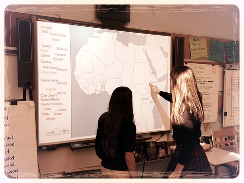 |
| 8th graders review for Africa test, December 2012 |
At the end of the prior school year (May of 2012), I had, out of curiosity, given my students blank maps of the United States, Europe, and the Middle East. Some results were funny (Hey, look, he put New Hampshire in Montana!) and others were distressing (Pretty much no one knew the Middle East.). My own knowledge of Africa, Asia, and any country that was once part of the USSR was fairly non-existent. (Confession: I once argued fairly vehemently to a fellow teacher that there were 5 provinces in Canada and about 20 countries in Africa. I was wrong. By a lot. I only taught English at the time, and he was and is a history teacher, but still, that's pretty bad.) It was clear to me that if we were going to learn about the larger world, we should start by actually knowing where places were.
I am what one online personality profiler called a mastermind. I excel at contingency planning, at starting something that has many steps and stages, and knowing what has to happen at each step along the way. In my case, if you hand me a complicated project (teach students 150+ countries), I will break it down, plan it out, and keep to the schedule. This might sound arrogant, but I think it's interesting to think about why this project appealed to me and might have scared someone else. When I thought about learning all the countries, I almost immediately broke it down into smaller stages, easily managed and mastered. (This strength, of course, becomes a weakness if someone tried to move me away from my plans and contingencies. It's not pretty.)
As with any new project, the start was slow. Many students needed to learn the 50 states, and I had to find blank maps to use for quizzes and tests. By November, when we started studying Africa, we pretty much had our system down.
For each continent, we set up an interactive spread in our social studies notebook. (I used maps from d-maps.com. The site is amazing. All maps pictured on this post came from there originally.) We listed the countries on one page, and attached two blank maps on the facing page. The bottom map was glued down, and an indentical map was taped on top of it. The point was for students to quiz themselves easily.
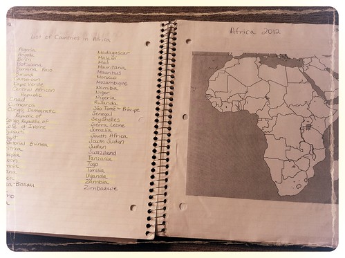 |
| This is from my notebook. The kids weren't always this neat. |
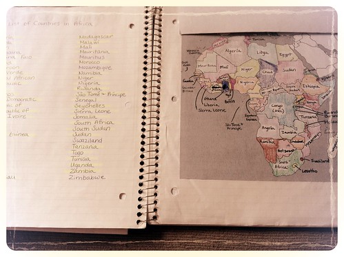 |
| The kindergarteners in after school care were very impressed with my coloring skills. |
I divided each continent into regions. To make life easier, and because the site was very popular with my students, I used the regional breakdowns in the geography games at Sheppard Software. Typically, this meant that the quiz each week covered 6-10 countries. We took a prequiz on Monday and a quiz on Friday. They were exactly the same, and I posted the answer key on Edmodo after the prequiz. All of this took up to 30 minutes on the first day of a continent (8th graders + tape + glue sticks = You'll need extra maps), but only 10 minutes on most other Mondays and Fridays. When we finished a continent, we spent a week reviewing and then took a test. At the end of the year I put all the countries on one massive final.
I still haven't actually covered the why, but this post is long enough. I'll post part 2 tomorrow, so please, let me know if you have any questions, either in the comments or on Twitter.
Currently reading: Middlemarch by George Eliot
Yesterday I read: Two awesome books. I finally finished Beyond Courage by Doreen Rappaport, about the Jewish resistance in WWII. I also read an advanced copy of a terrific collection of fiction and non-fiction called Open Mic: Rifs on Life Between Cultures in Ten Voices, edited by Mitali Perkins. You need this collection for your classroom.
*There were 156 countries on the final (Asia, Africa, Europe, Central and South America), plus at least a dozen bonus countries (tiny ones, like Vatican City.) I never found blank maps that worked for Oceania and other islands of the world, so we weren't able to do those. Next year!
Fantastic! I've bookmarked the d-map and Sheppard software sites to use in my geography class next school year. One site I've used that students really enjoy is http://www.travelpod.com/traveler-iq for practice and review. Great post, Lea!
ReplyDelete